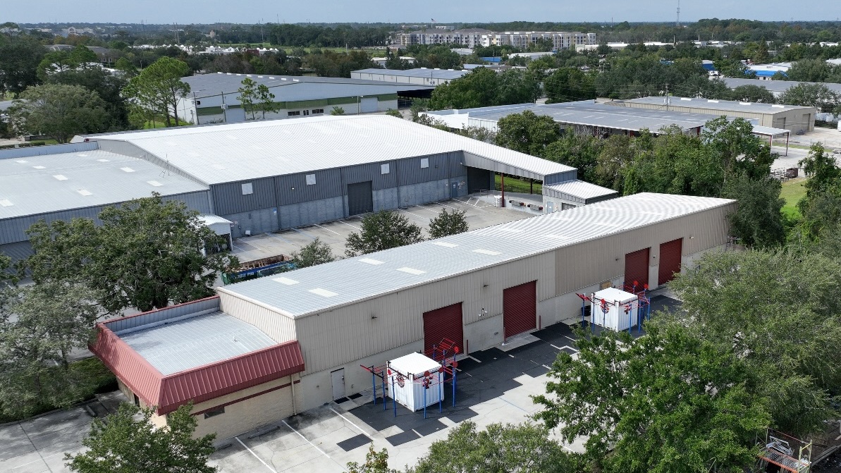
A 300,000-square-foot roof should not depend on where two people walked
Send a two-person crew onto one of the big distribution roofs along the Highway 370 corridor in Papillion and they will spend most of a day on it, and the report you get back still only reflects the path their boots happened to take. Aerial inspection changes the math. We fly the entire deck on a planned grid and capture every drain bowl, lap seam, pipe boot, curb, and rooftop unit in high-resolution stills — without setting foot on a membrane whose condition we have not confirmed yet. On a brittle, sun-baked roof or one hiding soft, saturated spots, staying off it until we know what is up there is a safety call before it is a productivity one.
The roofs where this earns its keep around the metro are the wide low-slope ones: the logistics and fulfillment buildings filling in near the I-80 and I-680 split, the multi-tenant industrial parks clustered around Eppley Airfield and the riverfront, the strip and power centers along the 168th Street and Maple corridors, and the sprawling school and athletic-complex roofs across the Millard and Bennington districts. Those are precisely the roofs where a hand walkover is slow, full of blind spots, and hard on both the crew and the membrane, and where one flight produces a complete, repeatable record in a fraction of the time.
What the thermal camera sees that your eyes cannot
The payload that matters most on these flights is the infrared sensor. Trapped moisture inside the roof assembly is the quiet failure that does the most expensive damage on a large low-slope roof, and from the surface it is nearly invisible. Water sneaks into the insulation through a split seam, a tired penetration, or a backed-up drain, and then it just sits. Wet insulation stores and releases heat differently than the dry insulation surrounding it. After a sunny day, as the roof gives up its heat through the evening, the saturated zones radiate that stored warmth more slowly and glow against the cooler dry field in the thermal image. That contrast is your moisture map.
We schedule the thermal pass for that evening cool-down window on purpose, because that is when the temperature split is sharpest and the wet areas read without ambiguity. What you get back is not a guess that the roof is wet somewhere. It is a drawn outline of where moisture has migrated inside the assembly — the one piece of information that separates a few hundred square feet of targeted cut-out and patch from a saturated field that has to come off wholesale. Before anyone commits to a scope, we confirm the thermal signatures with a moisture meter reading or a core sample taken on the ground, so the recommendation stands on verified wet area rather than the infrared alone.
An accurate moisture map rewrites the budget
Knowing exactly where the wet insulation lives changes the economics of the entire project. Saturated insulation has lost most of its R-value and will not dry out under a new membrane — recover over it and you have sealed the trouble inside, where it keeps eating the deck and feeding leaks. By mapping the wet zones before the work is scoped, we can draw a tear-out boundary that pulls the soaked material and recovers what is still sound, instead of defaulting to a full replacement the roof may not need or recovering one that is already too far gone. On a building this size, the line between repair-and-recover and full replacement is a six-figure decision, and it deserves to be made on data.
That same flight feeds replacement planning when replacement is the answer. The aerial imagery gives us accurate roof area, a full inventory of penetrations and rooftop units, and a documented record of existing conditions, so the specification and bid drawings reflect what is genuinely up there. That cuts down the surprise change orders and mid-project RFIs that surface when the only prior information was a hurried visual walk.
Flying it within the rules over Omaha airspace
We treat the airspace with the same care as the roof. Commercial drone work is flown under the FAA's Part 107 rules by a certificated remote pilot, and the Omaha metro has real airspace to honor. Eppley Airfield sits inside controlled airspace on the north side of downtown, and Offutt Air Force Base controls a large block of airspace south of the metro — both constrain where a drone may operate and how high. Where a survey falls inside controlled airspace, we secure the required authorization before we launch rather than flying first and explaining later. Visual line of sight, altitude ceilings, and a controlled ground area around the launch point are built into every flight plan.
On the ground we coordinate with building operations so tenants and staff know a flight is in progress, and we keep the launch and recovery zone clear of people and traffic. None of this adds much time to a routine survey, but it keeps the inspection above board and the liability where it belongs.
Documentation that survives an adjuster's review
After hail or a high-wind event tears through the metro, the drone's job shifts from diagnosis to evidence. We produce GPS-tagged imagery that pins each finding to a precise spot on the roof — hail bruising and its density across the field, torn or displaced membrane, lifted edge metal and coping, and damaged rooftop equipment — in the form commercial property adjusters expect to review. Because every image is geolocated and time-stamped, the claim package documents not only that damage exists but exactly where it is and how far it spreads, which is what moves a claim instead of stalling it.
We can assemble that package fast after a storm, and for an active leak or a pending claim we treat the flight as a priority. Whether you need a routine annual condition survey for capital planning, a moisture map ahead of a reroof decision, or storm evidence for an insurer, the deliverable is the same kind of clear, located, defensible record.
Drone roof inspection questions
Why is a drone better than a walkover?
It covers the whole roof on a consistent grid with no gaps, keeps crews off a membrane whose condition is still unknown, and is far faster on large buildings. It also makes the thermal moisture survey possible, which is not practical to do by hand across a big low-slope roof.
Can infrared really pinpoint where the roof is wet?
Yes, when it is flown right. During the evening cool-down, saturated insulation holds heat longer than the dry material around it and shows up as a warm signature in the thermal image. We verify those zones with a moisture meter or a core sample before scoping any work.
Do you need FAA clearance to fly in Omaha?
Every flight is conducted under FAA Part 107 by a licensed remote pilot. Parts of the metro fall inside the controlled airspace around Eppley Airfield and Offutt Air Force Base, and where a survey lands in that airspace we obtain the required authorization before launch.
What kinds of roofs benefit most?
Large flat commercial roofs get the most value — warehouses, distribution centers, retail and power centers, office complexes, and multi-building campuses. On small or steep roofs a hand inspection is already quick, so the drone matters less.
How quickly can you document a roof after a storm?
Storm documentation for an insurance claim is prioritized and can usually be flown within a day or two of a significant weather event. We confirm the exact turnaround when you call.
Ready to talk through a roof?
Tell us about the building and the roof problem. We'll document it and put a plan in writing — with an honest repair-vs-replace recommendation and no upsell pressure.